CANADA


ENGLISH
Lessons


PRESENTATION


Netherlands
Netherlands-Polders-Dykes
Netherlands-the Dutch
Canada-The Capital
Canada-Pink Lake
Canada-Superlatives
India
Cornwall


shifting-dunes-autstralia pickil4 piccd26 piccd7
pic43 pic42 pic4 perth-australia
  • 2508260226042610

About Canada’s Capital

Words

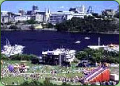
Ottawa, Canada’s Capital, sits on the border between the provinces of Ontario and Quebec in central Canada. It was made capital of the British colonial Province of Canada in 1857. In the 20th century, a much larger Capital region was created to serve as a frame for Canada’s Capital. Since 1969, Ottawa and Gatineau (two cities that face each other across the broad Ottawa River) and the surrounding urban and rural communities have been formally recognized as Canada’s Capital Region.

The Capital Region

  • encompasses 4,715 square kilometres of river valley, mountains, wetlands and fields
  • stretches out on both sides of the Ottawa River to include parts of two Canadian provinces — Ontario (to the south) and Quebec (to the north)
  • lies at 79 metres above sea level
  • enjoys a “continental” climate (hot and humid in summer, cold and snowy in winter)
  • contains two major cities — Ottawa and Gatineau — as well as numerous small towns
  • has a population of 1.081 million (as of 2000)
  • is one of Canada’s most bilingual communities, with nearly half a million people speaking both English and French
  • 1321


A capital is more than a city; it is an expression of the country in general and a gathering place for its citizens. Canada’s Capital Region belongs to all Canadians. Even more importantly, it represents them, as

  • The seat of government
  • A place of national symbols
  • Canada’s face to the world
  • A cultural showcase

Ottawa was named the capital of the Province of Canada in 1857. At this time, Ottawa was a plain little industrial town in the middle of nowhere. The transformation started in 1859, when work began on a series of grand new Parliament Buildings in Ottawa. The legislature of the Province of Canada sat for the first and last time in these new buildings in 1866. The very next year, Canada was created as a new independent nation, and the first government of the Dominion of Canada assembled in Ottawa. However, its history goes back much further than that. 

The Parliament Buildings of Ottawa form one of the most recognizable skylines in Canada. They stand at the top of a limestone escarpment that looms over the Ottawa River. The limestone was laid down thousands of years ago, when the whole of this valley lay at the bottom of the ancient Champlain Sea. Over the centuries, the sea retreated, the river gradually cut through the layers of limestone to form high cliffs, and great forests of red and white pine grew up. Today, the Ottawa River (the most important tributary of the St. Lawrence) runs like a spine through the Capital Region from west to east, forming the boundary of Ontario and Quebec. The Gatineau and Rideau rivers, and the Rideau Canal, attach like ribs from the north and south respectively.

To the North...

The Ottawa River parallels the rocky edge of the Canadian Shield, one of the world's oldest mountain ranges, now eroded into a low, softly rounded massif.

You can experience the Canadian Shield in Gatineau Park, 36,300 hectares of protected mountain, forest and lake just north of the urban Capital.

To the South...

Lies part of the flat, fertile Ottawa Valley, with its rich soils and wetlands.

You can see this landscape and learn about Canada's rural heritage by visiting the Greenbelt, a 20,000-hectare expanse of fields and forests in the southern part of the urban Capital.

Accessible Nature

16991700

In Canada's Capital, there is an extraordinary commitment both to preservation of the natural landscape and to finding ways to make it accessible to the public for recreation. The National Capital Commission (NCC) — federal steward and custodian of the Capital Region — has created an impressive portfolio of parks and green spaces.